There is no single province-wide number that tells you how far a building must sit from the water in Ontario. Municipal zoning, your local conservation authority and provincial regulations all weigh in together, and they do not always agree. Before you write an offer or sketch a building plan, check your Conservation Authority’s regulated-area maps and the municipality’s zoning by-law or Community Planning Permit System first.
TL;DR:
- Check conservation authority mapping before zoning: a project that meets municipal rules can still be refused if it lies inside a regulated area.
- Treat the 30 metre wetland buffer and 15 metre exceptions as starting points; flood setbacks depend on hazards, while small dock exemptions need local confirmation.
- For Innisfil properties fronting Lake Simcoe, check whether the Community Planning Permit System applies; it also governs docks, grading, and tree removal.
- Well and septic separation minimums commonly include 15, 30, or 60 metres, but system type, soil, slope, and bedrock can require greater distances.
- Make the offer conditional on conservation authority pre consultation, and allow time for professional reports; approvals commonly take several weeks to several months.
Who enforces shoreline setbacks: municipal zoning, conservation authorities and provincial law
What most buyers don’t realize is that shoreline development in Ontario answers to three separate authorities at once, and each one can say no on its own.
Municipalities set zoning categories, lot coverage rules and often a waterfront-specific overlay, sometimes marked with a “-W” suffix on the zoning map. Some towns, including Innisfil, fold zoning, minor variances and site plan control into one permit process for waterfront parcels. That system decides what gets built, where it sits on the lot and what it looks like once it’s there.
Conservation authorities work from a different angle entirely. They regulate areas prone to flooding, erosion and wetland impact, and their permit requirements apply whether or not a project already complies with municipal zoning. A shed that fits every zoning rule on the books can still be refused if it sits inside a conservation authority’s regulated area.
Provincial law sets the technical floor underneath both of those layers. The regulation under the Conservation Authorities Act defines how hazard lands are measured, including flood levels, erosion allowances and wetland buffers, and the Ontario Wells Regulation sets separation distances for water wells near shorelines.
Here’s the order that actually matters when you’re evaluating a lot:
- Conservation authority regulated-area status, because it can override what zoning otherwise allows.
- Municipal zoning and any waterfront suffix or Community Planning Permit System coverage.
- Provincial technical rules for hazard mapping, wetlands and private wells.
Skip the conservation authority check and you risk falling for a lot that looks buildable on paper but isn’t in practice.
Common numeric standards and examples you will see in Ontario rules
Ontario’s shoreline rules use recurring numbers, but every one of them comes with conditions attached, so treat these as working examples rather than guarantees for your specific lot.
The 30-metre wetland buffer appears throughout Ontario’s conservation framework. The provincial regulation under the Conservation Authorities Act establishes a 30-metre setback around wetlands in many cases, a figure that conservation authorities use as a starting point when mapping their regulated areas.
Flood-related hazard lines work differently again. Instead of a flat distance, the provincial regulation builds the hazard boundary from the predicted 100-year flood level, then adds allowances for wave uprush, long-term stable slope movement and, along the Great Lakes shoreline, a dynamic beach allowance. Two lots on the same street can carry different setback lines once those additions are calculated, because slope and erosion history differ parcel by parcel.
A few other numbers show up often enough to know:
- Some conservation authorities or municipal by-laws apply a tighter 15-metre buffer in limited, lower-risk circumstances.
- A floating seasonal dock of 10 square metres or less is commonly exempt from permit requirements under proposed provincial updates, though local conservation authorities still confirm this on a case-by-case basis.
- Zoning by-laws frequently layer their own minimum setback from the high-water mark on top of whatever the conservation authority requires.
None of these figures substitute for checking your specific parcel. A dock permit exemption that looks straightforward on Lake Simcoe can still trip buyers up at closing if the structure was never formally confirmed against current mapping, so verify before you assume a small structure is automatically exempt.
How a Community Planning Permit System changes what you can build on Lake Simcoe frontage
A Community Planning Permit System replaces the usual patchwork of zoning approval, minor variance applications and site plan control with one combined permit for the property. Innisfil applies its CPPS to residential properties with frontage on Lake Simcoe and to parts of Alcona, which covers a large share of the town’s shoreline.
Because a CPPS is exclusionary by design, anything not expressly permitted in the by-law is not permitted at all, which is a sharper standard than conventional zoning. Innisfil’s permit by-law spells out waterfront-specific criteria tied to its “-W” suffix, including expectations around native vegetation retention, erosion control measures and appropriate servicing solutions for the site.
A CPPS typically covers more ground than most buyers expect:
- New structures, additions and boathouses on shoreline-designated lots.
- Dock construction or replacement.
- Site alteration work, including grading and tree removal near the water.
What that means for you: a property’s base zoning tells only part of the story once CPPS applies. The permit by-law and its schedule maps carry the specific rules that decide whether your renovation, new boathouse or shoreline landscaping plan is allowed as drawn, or needs to be redesigned to fit the waterfront precinct criteria. Read the by-law itself, not just the zoning summary, before you assume a project is a simple approval.
Well and septic siting near shorelines: Ontario minimums and best practices
Wells and septic systems near shorelines answer to their own separation rules, and they matter just as much as building setbacks when you’re evaluating a waterfront lot.
Ontario’s Wells Regulation guidance lays out minimum horizontal separation distances between a well and a sewage system or other contaminant source, and those distances vary by system type and well construction. The tables commonly reference distances of 15 metres, 30 metres and 60 metres depending on whether the sewage system is a conventional septic bed, a raised system or something higher-risk.
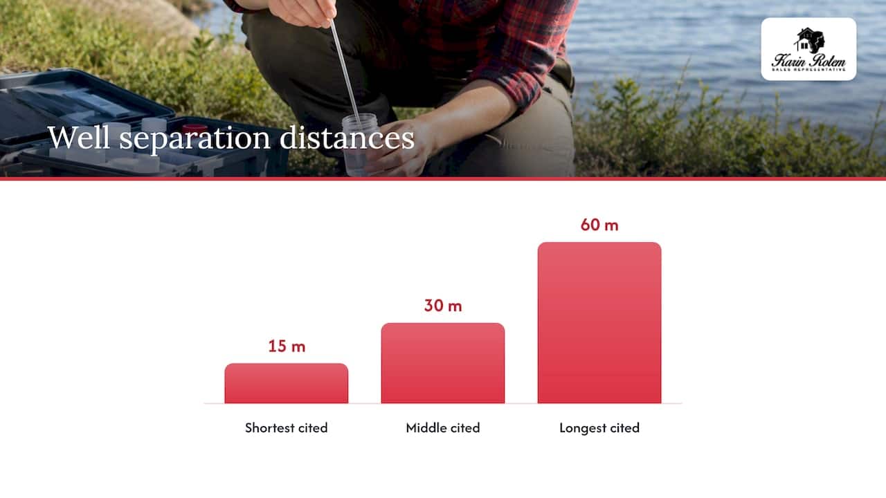
Those numbers are minimums, not recommendations. Bedrock depth, slope and soil type near a shoreline can all push the safe distance well past the regulatory floor, and a lot with thin soil over fractured bedrock behaves very differently from a flat, deep-soil site even at the same nominal setback.
A few things worth keeping in mind when you’re assessing a well on waterfront property:
- Separation distances depend on both well type and sewage system type, so the same lot can have more than one applicable minimum.
- Minimum setbacks protect against contamination risk, not against every site-specific hazard.
- A professional siting assessment, ideally from a geoscientist or engineer familiar with the local geology, can identify where the regulatory minimum isn’t enough.
Pro Tip: Where the lot allows it, site the well at a higher elevation than the septic system and keep it easily accessible for future servicing, since shoreline terrain often limits where equipment can reach.
Typical permit pathway, timelines and costs for shoreline work
Approvals near the water tend to follow a predictable sequence, and knowing the order helps you build realistic timelines into an offer.
- Confirm whether the lot falls inside a conservation authority regulated area using the authority’s interactive mapping tool.
- Pre-consult with both the conservation authority and the municipality before submitting anything formal, since this step often surfaces issues early and saves a redesign later.
- Apply for a conservation authority permit if the regulated-area check comes back positive, typically including a site plan, erosion control measures and any required restoration work.
- Move through municipal review, whether that’s a standard zoning and building permit process or a combined Community Planning Permit System application.
- Secure the building permit once zoning and conservation authority conditions are satisfied.
Pre-consultation to final permit commonly runs several weeks to several months, and the biggest driver of delay is usually an incomplete application or a project that needs redesign to meet erosion or vegetation conditions. Costs beyond the permit fee itself often include professional site studies, erosion control works and, in some cases, mandatory shoreline restoration as a condition of approval. If you’re selling a waterfront home with pending or unresolved permit items, build that timeline into your closing expectations rather than assuming it will resolve quickly.
How to check setback rules and permit risk for a specific lot before you buy
A property-specific check takes an afternoon and can save weeks of surprises after an accepted offer.
- Pull the municipal zoning schedule and Official Plan designation for the parcel, and note any waterfront suffix or hazard overlay shown on the map.
- Check the local conservation authority’s interactive mapping tool, whether that’s Lake Simcoe Region Conservation Authority, Nottawasaga Valley Conservation Authority or another authority covering the watershed, for regulated-area or hazard overlays.
- Confirm whether provincial rules apply beyond the basics, including Conservation Authorities Act hazard definitions, Wells Regulation separation distances and whether the municipality’s Community Planning Permit System by-law covers the property.
- Commission a professional assessment where any of those checks raise a flag, covering shore conditions, septic performance and well siting.
Build in protection while you’re still negotiating: a conditional offer with a conservation authority pre-consult clause, plus enough time allowance for professional reports to come back, keeps you from being locked into a deal before you know what the lot will actually permit. Our pre-offer checklist for waterfront buyers walks through these same checks in more detail.
What I tell my clients: real checks from Karin Rotem’s team on Toronto and Innisfil waterfront
What I tell my clients before they fall in love with a shoreline lot is that the regulatory check happens before the offer, not after.
Our pre-offer process on waterfront properties runs through the same core items every time:
- Conservation authority mapping to confirm regulated-area status.
- Community Planning Permit System applicability where the municipality uses one.
- Permit history on any existing boathouse or dock, since undocumented structures create closing complications.
- Septic and well siting relative to current regulatory minimums.
The surprises we see most often involve grandfathered boathouses that predate current zoning, shore road allowances that complicate who actually controls the waterline, and shoreline work done without a permit years before a sale. We typically recommend a conditional offer clause tied to a conservation authority pre-consult, with enough time built in for a septic or well inspection to come back before conditions are waived. Coordinating those professionals early, rather than scrambling after an accepted offer, is what keeps a waterfront transaction on schedule.
Why conservative shoreline planning protects value over the long run
What most buyers don’t realize is that the setback rules working against their renovation plans today are often the same rules protecting their property value tomorrow. A shoreline with intact natural vegetation and a stable, unmodified bank tends to hold up better against erosion and ice damage than one that’s been stripped and hardened, and that difference shows up in maintenance costs over a decade of ownership, not just in a permit application.
That doesn’t mean every constraint is worth accepting without question. A variance or a mitigation plan can make sense when a project genuinely improves on the status quo, say by reducing hard surface near the water or restoring a degraded bank. The difference is in the approach: work with the conservation authority early, bring a plan that addresses their actual concerns, and you’ll get a far better outcome than fighting the process after the fact.
— Felix
How our team helps you navigate shoreline rules before you buy
We built our pre-offer process specifically around the gap most buyers fall into: falling for a waterfront property before anyone has confirmed what the regulations actually allow on it. Rather than leaving you to piece together zoning schedules, conservation authority maps and well regulations on your own, we run those checks as part of evaluating a property with you, so you know the real picture before you’re locked into an offer.
Our focus on Innisfil, Lake Simcoe and the Friday Harbour community means we’ve walked this process on dozens of comparable lots, and we know which conservation authority contacts, municipal departments and local professionals to bring in when a question needs a fast answer.
If you’re considering a shoreline property:
- We’ll run a property-specific review of zoning, conservation authority status and permit history before you write an offer.
- We coordinate pre-consultations with the relevant conservation authority and municipality on your behalf.
- We connect you with trusted local professionals for shore, septic and well assessments when the lot calls for one.
Reach out through Karinrotem to start a pre-offer risk review on a specific waterfront property, or browse our current Friday Harbour listings to see what’s available now.
This article is general information, not a substitute for advice from a qualified lawyer. Consult a qualified legal professional about your own circumstances before acting on anything here.
FAQ
How close can you build to a property line in Ontario?
Minimum distances from a property line, known as side and rear yard setbacks, are set by the municipal zoning by-law and vary by zone and lot type. They are separate from waterfront setbacks, which are governed additionally by conservation authority regulations, so a waterfront lot typically has both a property line setback and a shoreline setback to satisfy.
What are the new rules in Ontario for 2026?
Ontario has been updating conservation authority regulations and related guidance, including proposed changes discussed in the ERO notice on minister’s regulations under the Conservation Authorities Act, which touch on wetland buffers and exemptions for small structures like seasonal docks. Specific requirements still depend on your municipality and local conservation authority, so confirm current by-laws and mapping directly before relying on any summary.
Can you own waterfront property in Canada?
Yes, Canadian citizens and permanent residents can own waterfront property, including on lakes like Simcoe, subject to the same zoning, conservation authority and provincial rules that apply to any shoreline development. Ownership of the shoreline itself can be affected by features like a shore road allowance, which is worth confirming before you buy.
What are the regulations for water wells near shorelines in Ontario?
Ontario’s Wells Regulation sets minimum horizontal separation distances between a well and a sewage system or other contaminant source, with common minimums around 15 metres, 30 metres or 60 metres depending on the system type. These are minimums only, and a professional site assessment can determine whether local geology calls for a larger setback.
Sources
- Community Planning Permit System | Town of Innisfil
- Regulation under the Conservation Authorities Act (O. Reg. 240/41)